LIVE
Quad Leaders Meet in Manila Today in First Summit in Two Years  •  United Airlines Hit by Systemwide Outage  •  Ramayana Crosses 1,437 Crore Worldwide  • 
World

6.6-Magnitude Earthquake Strikes Near Tual in Eastern Indonesia

By Toijam Bimoljit Singh • 17 November 2026 • 5 min read

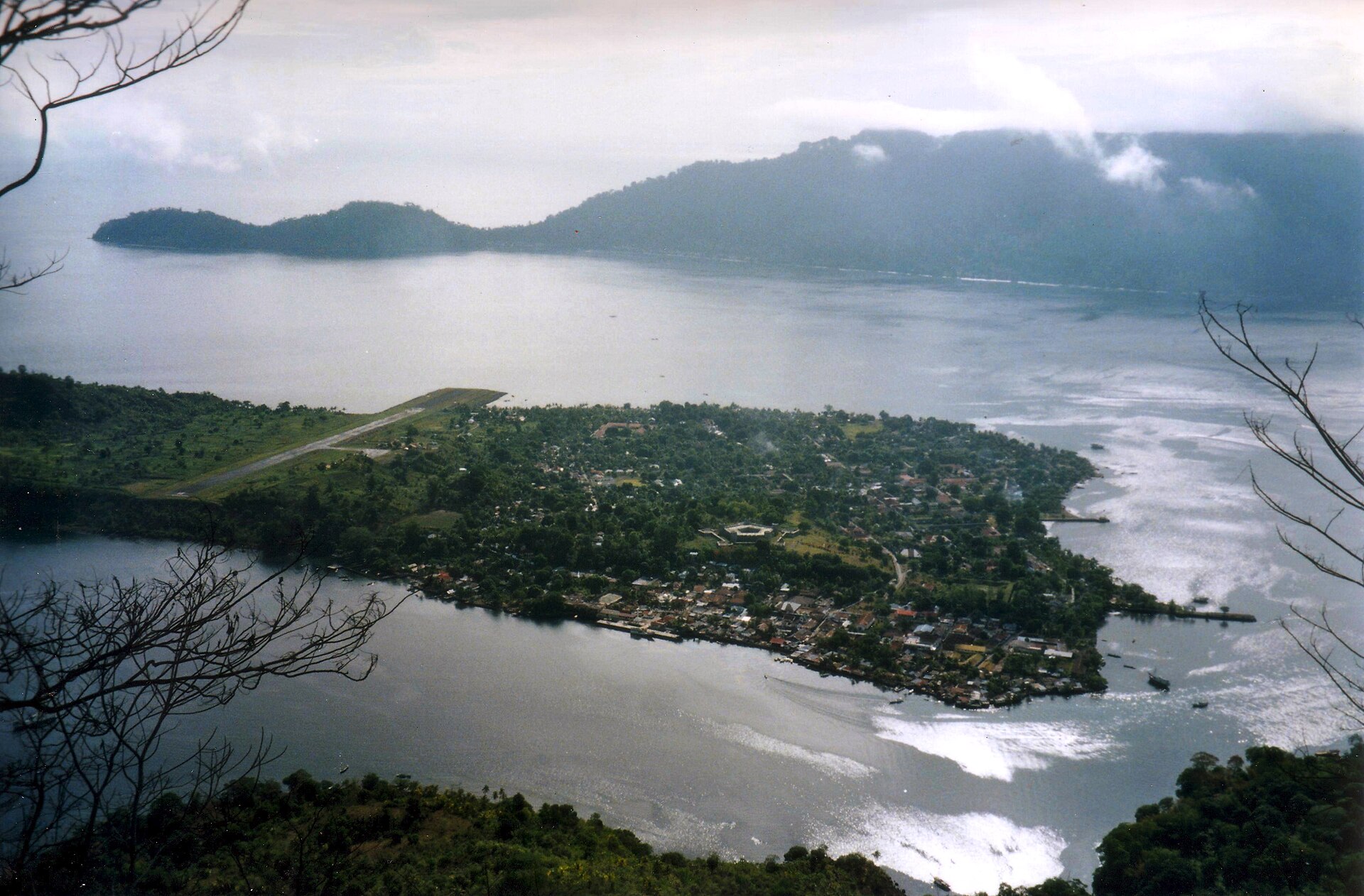
A wide view of the Banda Islands from the peak of Gunung Api volcano, with Banda Neira in the centre and Lontar Island behind it

Photo: Anton Leddin, CC BY-SA 3.0, via Wikimedia Commons — the Banda Islands in the Banda Sea, viewed from the peak of Gunung Api volcano in January 1998. The photo is from an earlier date, not the earthquake itself.

TL;DR — the direct answer: A magnitude 6.6 earthquake struck off eastern Indonesia early on Tuesday, 17 November, in the Banda Sea west-southwest of Tual. The United States Geological Survey put the quake at 151 km west-southwest of Tual, in Maluku province, at 21:11 UTC on Monday, which was 06:11 on Tuesday morning local time and 02:41 IST. Indonesia's meteorology agency, BMKG, recorded the same quake at a higher magnitude of 7.1 and said it had no tsunami potential, and the USGS issued a Green alert, meaning a low likelihood of casualties or damage. Shaking was felt across towns in Maluku, but no damage or casualties had been reported by Tuesday morning, and no tsunami warning was issued.

What happened: The quake struck at 21:11 UTC on Monday, 16 November, which was 06:11 on Tuesday morning in the Asia/Jayapura time zone and 04:11 in western Indonesian time. The USGS placed the epicentre at 6.03 degrees south and 131.45 degrees east, in the Banda Sea, and listed the depth at 68 km in its reviewed listing. The agency marked the event as reviewed, meaning a USGS analyst had signed off on the magnitude, location and depth. BMKG recorded the same origin time but put the magnitude at 7.1 and the depth at 115 km, about 130 km southwest of Maluku Tenggara, and said the earthquake did not have tsunami potential. The USGS gave the quake a Green alert for shaking-related deaths and economic losses, its lowest level, and estimated that about 8,100 people were exposed to moderate shaking, with no estimated exposure to severe shaking. The agency logged 10 felt reports, and its data showed a maximum reported shaking intensity of about 4.9 on the Modified Mercalli scale, a level that points to light to moderate shaking near the closest land.

Why it's trending: It was the largest earthquake recorded anywhere in the world on Tuesday, and the gap between the two official readings has drawn attention: the USGS says 6.6, while Indonesia's own agency says 7.1. That difference is common for offshore quakes, where agencies use different sensor networks and methods, but it can look confusing in the first hours after a big tremor. The quake also struck a remote stretch of sea, about 150 km from the nearest city, so early information was thin and people searched for news of damage and any tsunami threat. Eastern Indonesia sits in one of the most earthquake-prone parts of the world, and a quake of this size near populated islands always raises the same immediate questions: how strong, how deep, and is a tsunami coming.

Background / context: Indonesia records frequent earthquakes because it sits where several tectonic plates meet, and the Banda Sea is one of its most active seismic zones. Tual is a port city in the Kai Islands, in Maluku province, and the epicentre lay offshore to its west-southwest, in the waters between the Kai Islands and the Tanimbar Islands. The region is sparsely covered by news outlets, so reports from smaller islands closer to the epicentre can take time to reach national agencies and newsrooms. BMKG reported weak shaking at intensity III in Tual, Saumlaki, Tiakur, Dobo, Sorong, Manokwari, South Manokwari, Bintuni, Fakfak and Kaimana, and at intensity II in Nabire and Serui. Intensity III shaking is felt indoors by some people, like the passing of a light truck, and rarely causes damage. The quake was also listed by seismologists as striking the Kepulauan Tanimbar region, the island group south of the epicentre.

What we know / what's unconfirmed: Confirmed: the magnitude of 6.6 from the USGS and 7.1 from BMKG, the time of 21:11 UTC on Monday, the epicentre about 151 km west-southwest of Tual in the Banda Sea, that BMKG said the quake had no tsunami potential, that the USGS set no tsunami flag and issued a Green alert, and the felt intensities reported by BMKG across Maluku towns. No damage or casualties had been reported by Tuesday morning. Unconfirmed: whether any damage occurred on smaller islands nearer the epicentre, where reports take longer to arrive, and the final figures for magnitude and depth, which agencies often revise as more data comes in. The depth figures differ between the two agencies, 68 km from the USGS and 115 km from BMKG, and the early USGS data also carried a shallower 35 km reading before review. None of the reports checked so far mention injuries, collapsed buildings or a tsunami.

What happens next: BMKG and the USGS will keep monitoring the area for aftershocks, which commonly follow a quake of this size, and local authorities in Maluku will check the islands nearest the epicentre for damage. With no tsunami warning issued and only weak to moderate shaking reported in towns, the expectation is that the quake caused little or no damage, but that will only be confirmed once reports come in from the remoter islands. If the agencies revise their readings, the magnitude and depth figures may change slightly. For now, the advice for people in the region is the usual one after a strong offshore quake: stay alert for official updates and be ready for aftershocks.

Frequently asked questions

Q: How strong was the earthquake?
A: The USGS recorded it at magnitude 6.6, while Indonesia's BMKG recorded it at magnitude 7.1. Such differences between agencies are common for offshore earthquakes.

Q: When and where did it strike?
A: At 21:11 UTC on Monday, 16 November, which was 06:11 on Tuesday morning local time. The epicentre was about 151 km west-southwest of Tual, in the Banda Sea off eastern Indonesia.

Q: Was there a tsunami warning?
A: No. BMKG said the earthquake had no tsunami potential, and the USGS set no tsunami flag on the event.

Q: Was anyone hurt or was anything damaged?
A: No casualties or damage had been reported by Tuesday morning. The USGS issued a Green alert, meaning a low likelihood of casualties or damage.

Q: Why do the USGS and BMKG figures differ?
A: The two agencies use different sensor networks and calculation methods, and offshore quakes are often revised as more data arrives. BMKG put the depth at 115 km, while the USGS reviewed listing put it at 68 km.

Sources: The Watchers — M6.6 earthquake hits the Banda Sea 148 km west-southwest of Tual, Indonesia, The Times of India — Indonesia's Tual hit by 6.6 magnitude earthquake, and The Economic Times — Magnitude 6.6 earthquake strikes Indonesia's Tual region, says USGS.

← Back home